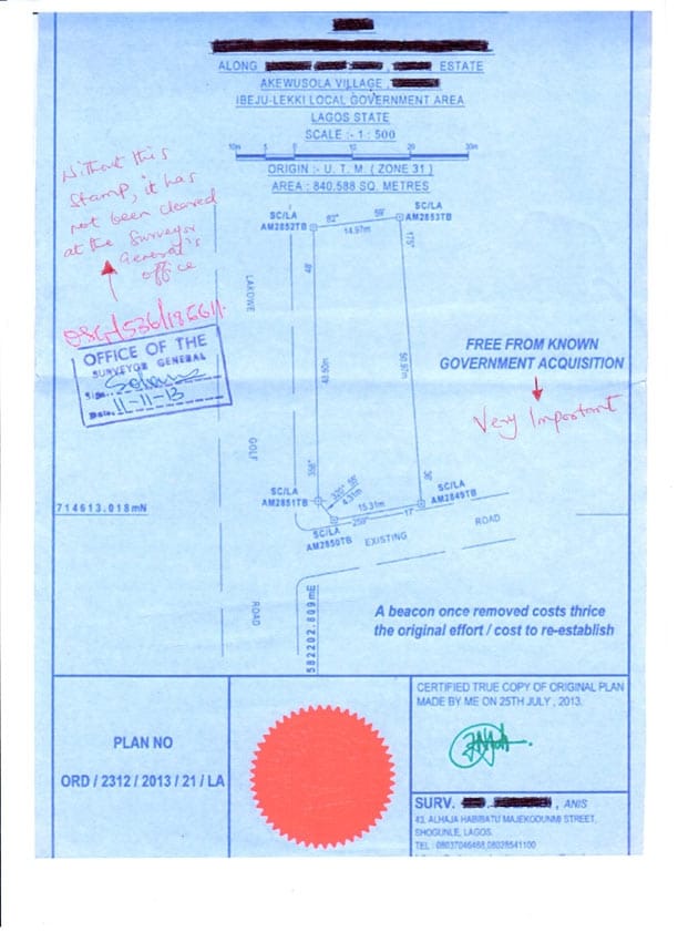
Survey Plan is one of the most vital documents to denote property ownership boundaries. Ownership of land revolves around having an identifiable parcel of land with well-defined boundaries. These boundaries cannot be interpreted or understood without the aid of a survey plan. In this regard, you cannot own land without properly demarcated boundaries and landmarks.
.
Table of Contents
A survey plan is a legal document that communicates, defines and demarcates the boundaries, shapes and topographies of land parcels.

The strength of a survey plan lies in its ability to communicate how unseen boundaries, physical site features and abstract title information relate spatially to one another. It enables data from a variety of important sources to be illustrated visually on a specialized map.
The most important feature of a survey plan is that it displays the legal boundaries of the property, a factor that is often neglected until boundary issue arises.
A survey plan enables you to identify:
- The size of a property
- The shape of a property
- The location of rights of ways and easements
- Topography of the Land
- The existing road around the property
- The exact location of the land with reference to the global coordinate system.
A survey plan can reveal hidden title deficiencies, highlight building encroachments and demonstrate authentic property dimensions.
If you are buying a land or a built-up property for the long term or short term, a survey plan might be useful in these regards;
-
Property Disposal or Acquisition
-
Title Deed Preparation
-
Land Information Certificate Processing.
-
Governor’s Consent Processing
-
Certificate of Occupancy (C of O) Processing & Perfection.
-
Architectural Design
-
Layout Design
-
Road Constriction
-
Loan / Mortgage Application
-
Preparation of Deed of Gift ( where land is the gift)
If you are selling your home, provide a copy of your survey plan to prospective buyers to assist their due diligence process. Survey plans are highly valuable tools for;
-
Real Estate Consultants
-
Lawyers
-
Banks
-
Government agencies
A survey plan is an essential property ownership document that will help you protect your property rights and enjoy your land with confidence and peace of mind.
Features of a Professional Survey Plan
-
Name of the Owner of the Land
-
Size of the Land
-
Address of the Land
-
Survey Beacon Numbers
-
A registered Seal of the Surveyor that prepared the Survey plan.
-
Signature of the Surveyor that prepared the Survey plan.
-
The Date the Survey was Prepared
-
Survey Plan Number
-
Geographic Coordinate Number (Usually in UTM – Universal Traverse Mercator)
-
Stamp Showing if the Land is Free from Government or Not.
Registered Survey vs Provisional Survey
A survey is said to be registered after it has been logged and recorded in the office of the Surveyor-General of the State (The Nigerian Standard/Process) while a Provisional Surveys are not registered at the Office of the Surveyor-General of the State of the Nigerian Federation.
Registered surveys are usually expensive compared to the provisional survey, while provisional surveys are cheaper, because a government registration is not involved, and little information is usually stated on the survey plan document.
Learning Review
A Survey plan is a document that measures the boundary of a parcel of land to give an accurate measurement and description of that land. The people that handle survey issues are Surveyors and they are regulated by the office of the Surveyor-General of the State where they operate. A standard survey plan must contain the following information:
As a learning recap, never forget to explore;
-
Name of the Owner of the Land
-
Size of the Land
-
Address of the Land
-
Survey Beacon Numbers
-
A registered Seal of the Survey
-
Signature of the Surveyor
-
The Date the Survey was Prepared
-
Survey Plan Number
-
Geographic Coordinate Number (Usually in UTM – Universal Traverse Mercator)
-
Stamp Showing if the Land is Free from Government or Not.
Disclaimer;
The contents of this article are for informational purposes only. Always consult a registered Land Surveyor before embarking on any land surveying project.
Other Useful Contents:
What is an Approved Layout Plan
13 Documents you need to Process a C of O (Certificate of Occupancy ) for your Property in Nigeria
Our Real Estate Marketing and Development Consulting Partner
Author Profile

- I am Bolaji Afolabi, a Partner at Globalclique, and a CIO @ Ibugbe and Partners - Pan African Real Estate + Technology + HR Consulting Group. Bolaji is celebrated for his expertise in seamlessly blending human capital with cutting-edge technologies, and also providing professional advisory services.
Latest entries
 REAL ESTATEApril 4, 2024Understanding Real Estate Joint Ventures: A Comprehensive Guide
 GROWTH HACKINGSeptember 5, 20228 Powerful Ways to Look Good and Feel Great
 GROWTH HACKINGSeptember 5, 2022The 3 Core Types of Income
 GROWTH HACKINGSeptember 5, 2022Smart P.O.M Model for Business Success


One thought on “Survey Plan ? Don’t buy a Land in Nigeria without it”